As a developing nation we are faced with tremendous challenges to meet the requirements of a rapidly growing population, this has led to the need for bigger infrastructure. We are constantly building new roads and bridges or widening the existing once. Many a times we seldom pay attention to the design of such projects with regard to their feasibility in the near term as well as long term. Goa has been particularly witnessing tremendous infrastructural developments lately with the expansion of the western expressway and building of new bridges across rivers from north to south. The proposed western bypass has been infamous for several reasons due to conflicts of interest among the local people, environmentalists and the government. An example of such a dispute is the stalling of construction of the highway stretch at Seraulim going up to Navelim on the outskirts of Margao city, The local people have been demanding that the highway be constructed on stilts to allow free passage of water underneath whereas the project proponents claim that this will steeply inflate the allocated budget for the project, with the matters now in court.
A preliminary study was conducted to understand the grievances raised by the people and collect supporting scientific data. The data analysed include SRTM Digital Elevation Model, Sentinel-2 Satellite imagery taken on 22/09/2019 and field photographs taken during the last flooding event.
A contour map was prepared with the SRTM digital elevation data and a 3D model was made for visualization. The contours indicate that the pending stretch of highway is passing through a narrow passage of low lying area surrounded on both sides by local highs. The proposed highway also runs parallel to the river Sal and cuts across it at Navelim and near the wholesale fish market in Margao.
Figure 1: Contour map of the area at 5m interval

Figure 2: 3D Model of the area derived from SRTM 30m elevation data.
A cloud free Sentinel-II satellite image of the area was acquired on 22/09/2019. Though the peak of flooding occurred much earlier in June and subsequent other flooding events occurred in July and August. Useful high resolution optical imagery was unavailable owing to the presence of clouds. The infrared band was analyzed by applying a threshold method to extract a binary water mask around a buffer of 2km of the proposed Highway. Water strongly absorbs infrared leading to dark pixels whereas healthy vegetation reflects it strongly leading to bright pixels in the satellite imagery. While interpreting the imagery a caution is to be exercised while differentiating built up areas such as roads, roofs of buildings and water as they sometimes have similar reflectance in infrared band. Another possible source of error could arise from the presence of shadows from clouds and tall buildings. The water mask was subsequently processed and interpreted to eliminate errors in classification.
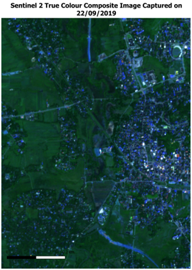

The analysis of Sentinel-II image indicates extensive flooding along the path of the proposed highway. The river section running parallel to the proposed highway is seen to be overflowing its banks at Mungul bridge due to excessive runoff from the surrounding areas. The narrowing of the river channel at Khareabandh resulting in flooding of the adjoining low lying area is also very evident.
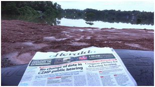
Field photographs captured by the locals were further used to validate the data output.


The observations above bring forth several concerns with regards to the nature of the area under investigation and the implications of the proposed project, which must be dealt with to mitigate the hazards and minimize losses. The hazards and risks include, loss of human life due to flooding, Disruption of Road Network, Risk to vehicles and passengers trying to pass through floodwaters on the road, Flooding of surrounding urban area. Prolonged Water logging/stagnation, Losses of agricultural land due to land filling, Displacement of people living within high risks areas, the likely recurring damage to crops due to rise in water table and cultivable land getting flooded.


.png)
No comments:
Post a Comment